Daniel MEGE
RESEARCH


|
You ? |
Pierre-Antoine Tesson A former student of University of Nantes, Pierre-Antoine is since 2018 a PhD student in planetary geology (volcanic, tectonic and hydrothermal processes on Mars) at the Polish Academy of Sciences, Wroclaw. |
Marta Ciazela Hired in 2014-2015 to work on thermal inertia
methods for geological applications in complex
landscapes on Mars at the Polish Academy
of Sciences, Wroclaw, she is AGAIN a postdoc with us
to work n varaition of surface temperatures on Mars
through time. |
|
Jakub Ciazela
A former PhD student at University of
Hanover, specialised in the geochemistry of metals at
ocean spreading centres. Currently a postdoc at the
Polish Academy of Scences, Wroclaw, working on mineral
resources on Mars. |
Hired in 2012 as a research scientist
working on glacial processes on Earth and Mars at the
Polish Academy of Sciences, Wroclaw. Now a Research
Engineer at LPG Nantes. |
Hired in 2012 as a as a research scientist working
on periglacial processes on Earth and Mars at the
Polish Academy of Sciences, Wroclaw. Now Maître de
conférences at Université Paris-Sud. |
|
Hired in 2012 as a PhD student in planetary
geology (landslide propagation) at the Polish Academy
of Sciences, Wroclaw. PhD defended in 2016. |
Hired in 2012 as a PhD student in planetary geology (geological syntheses) at the Polish Academy of Sciences, Wroclaw. |
Hired in 2012 as a PhD student in planetary geology
(gravitational spreading) at the Polish Academy of
Sciences, Wroclaw. PhD defended in 2015. |
|
Hired in 2012 as a PhD student in
planetary geology (basalt alteration) at the Polish
Academy of Sciences, Wroclaw. Defended in 2016. |
Hired in 2010-11 as a Master student at LPGNantes in geomorphometry, and in 2011-12 in planetary geology. |
Hired in 2010 as a PhD student in planetary geology
(geomorphology and structural geology) at the Polish
Academy of Sciences, Wroclaw. PhD defended in 2015. |
|
Hired as a postdoc in Planetary geology at LPGNantes. Research scientist at Polish Academy of Sciences since January 2010. |
Hired as a PhD student on granular flow modelling
at LPGNantes and IPGP. Currently a CNRS researcher at
IPGP. |
Hired as a PhD student in planetary geology at
LPGNantes. Currently Maître de conférences at LPG
Nantes. |
|
Hired as a Master student on scientific observations by Henry de Monfreid in the Red Sea at LPGNantes. GIS specialist, Project Manager since 2010. |
Hired as a Master student at LPGNantes, working on gravitational spreading in eastern Ethiopia. In 2013, postdoc at University of Toulouse in hydrogeology and infrared spectroscopy. |
Hired at Addis Ababa as a Master student working on
the hydrogeology of the Bale Mountains, Ethiopia, in
2004. Currently Assistant Professor at Tulane
University Louisiana. |
Marion Massé
Glacial processes on Earth and Mars
|
Effect of hydration of a dry FeSO4/basalt powder mixture on near-infrared spectrum by injection of various amounts of water vapor. (Massé et al., LPSC 2012). |
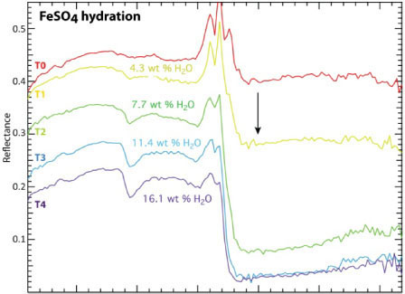 |
Marion presently has two main research axis: formation of sulphates in in glacial environment on Mars and Earth, and spectral signature of brines flowing on basalt soil. The latter topic is investigated using experiments of basalt hydration by brine and dehydration in controled, Martian-like, atmosphere conditions (composition, pressure, temperature) conducted at the Planetology Lab at University of Grenoble (IPAG), France. They aim at understanding the expected near-infrared specral signature of Recurrent Slope Linae (RSL) on Mars in a collaboration with Alfred McEwen at Lunar and Planetary Laboratory in Tucson.
Antoine Séjourné
Periglacial processes on Earth and Mars
|
Thermokarst lakes: how do they evolve through time, what is the effect of global warming on Earth? |
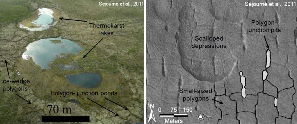 |
The northern mid-latitudes of Mars display many perigalcial landforms; Antoine has been investigating analogues of terrestrial thermokarst lakes in Yakutia and Canada (left image above) and their evolution through time. Sequencial acquisition of satellite images of thermokarst lakes near Yakutsk and field measurements made possible by the Permafrost Institute in Yakutsk allow annual variations of thermokarst lakes to be evaluated.
Timur Borikov
Propagation of debris flows on Mars

Discrete element modelling of granular flow between two rigid walls.
Why the runout distance of Martian landslides is longer than predicted by experiments requires a mechanism to lower the friction at the base of the debris flow. The presence of an erodible bed at the interface between the debris flow and the basement erosion can increase the propagation distance, however this has been shown to work for slope angles > 10° only (Farin et al., AGU 2012). On Mars, many debris flows propagate on gentler slopes. Timur is investigating alternative mechanisms that could cause the increased propagation distance for such flows. He is implementing a discrete element approach, using a code developed by Patrick Richard (Institute of Physics at University of Rennes, France) to study debris flow propagation using different values for mechanical parameters. He will compare the results with results from models of landslide propagation presented by Lucas et al. (JGR 2011) using the SHALTOP granular code (Mangeney et al., JGR 2007), from published experiments, and from observations on Mars. Timur's work is co-supervised by Anne Mangeney et IPGP, Paris.
Krzysztof Debniak
A Valles Marineris synthesis
|
Structural map of part of Valles Marineris (Mège and Bourgeois, 2011) |
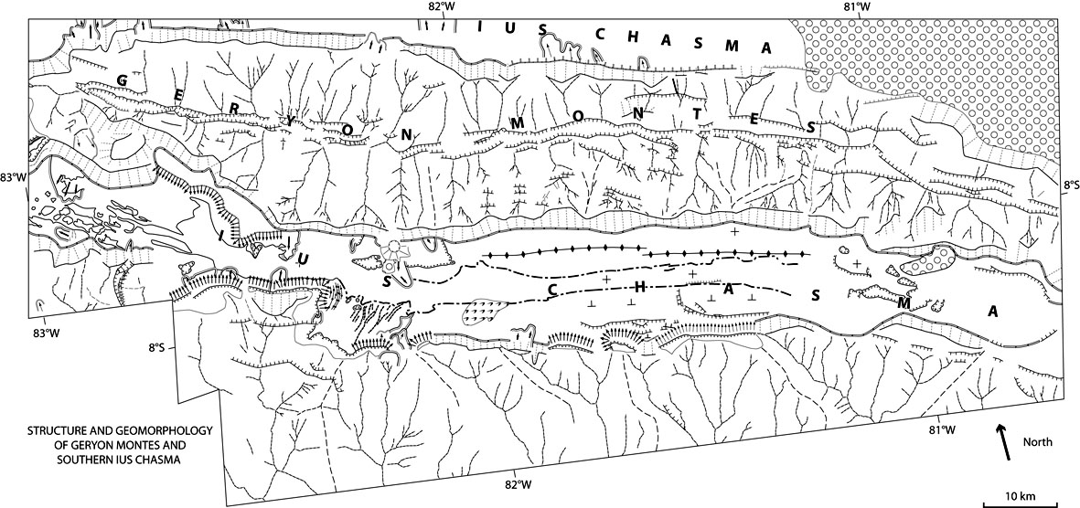 |
The Valles Marineris giant trough system opens an up to 10-km deep window into the geology of the Martian crust. Tectonic, volcanic, sedimentary, and erosional processes spanning a range of ~4 g.y. have been recorded along the trough walls and on their floor. They testify to a succession of paleo-environments and paleoclimates which have been a matter of debates since the Viking era. Far from being closed, these debates have been enriched and complexified by the accumulation of the subsequent datasets obtained by the Mars Global Surveyor (MGS), Mars Odyssey, Mars Express (MEx), and Mars Reconnaissance Orbiter (MRO) spacecrafts. The abundance of datasets, their diversity, very high resolution of visible imagery, as well as the small number of researchers involved in Valles Marineris exploration, contributed to thematic and geographic dispersion of studies to such a point that synthesis and correlation of previous works are necessary. From this point, new views and a new coherent framework for Valles Marineris evolution can emerge. The undertaken study consists in the realization of a GIS of Valles Marineris that will include mosaics of selected datasets (MRO/CTX VIS images, Mars Odyssey/Themis night-time IR images, MGS/MOLA PEDR and DEM, MEx/HRSC images and DEMs, MRO/HiRISE images and DEMs), existing regional maps (MEx/OMEGA and MRO/CRISM mineral maps, gravity and magnetic maps), new regional or local maps (CTX DEMs, climate/paleoclimate models), basic geomorphologic description layers (in which geomorphology is not interpreted in terms of processes and environments), and advanced geomorphologic and geologic interpretation layers (in which processes and paleoenvironmental interpretations are proposed by the authors).
Magdalena Makowska
Simulations of deep-seated gravitational spreading on Earth and Mars
|
Magda is measuring an uphill-facing scarp produced by gravitational spreading in the Slovakian Tatras using WADGPS, September 2012. |
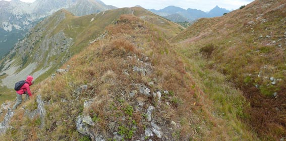 |
Development of tectonic features by deep-seated gravitational spreading is investigated on Earth and Mars using FEM simulation of gravitational spreading on Earth and Mars. Terrestrial cases are constrained by measurements made in the field in the Tatra Mountains of Poland and Slovakia. Martian cases are constrained by available orbital imagery and CTX DEMs generated by Antoine Lucas. Magda is co-supervised by Prof. Frédéric Gueydan at Géosciences Montpellier laboratory in France.
Marta Ski?cim
Nanoscopic characterisation of basalt alteration in different environments
|
AFM image of a basalt sample from Ogaden. |
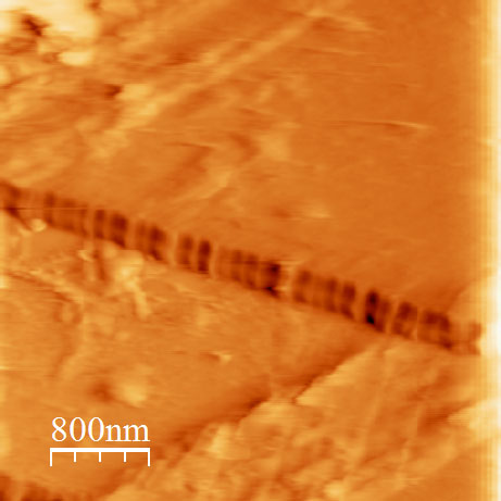 |
Basalt alterates to clays such as montmorillonite or nontronite. From near-infrared spectra of the surface of Mars (data from Mars Express/OMEGA and MRO/CRISM), it is inferred that some of the basalts that are thought to make the crust of Mars are altered and that such phyllosilicates have formed. The spectra are unable, unfortunately, to give information as to the basalt weathering conditions. The phyllosilicates interpreted from the spetra can form in a variety of environments. Marta is investigating the nanostructure of terrestrial basalts altered in contrasted environments to examine whether something in their structure is diagnostic of the alteration environment. She is co-supervised by Profs. Leszek Markowski and Bogdan Barwi?ski at the Institute of Experimental Physics of the University of Wroc?aw.
Thomas Guidat
Geomorphometry, Planetary geology
|
Along-stream elevation of the Shebele river valley in central Ogaden compared with the elevation of the base of the Shebele valley during Mio-Pliocene, inferred from meanders fossilized by lava flow (Guidat, TER LPGNantes 2011). |
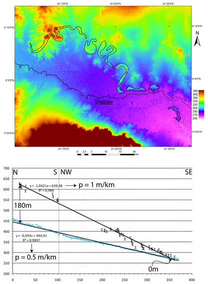 |
During the first year o his master's degree in 2010-2011, Thomas Guidat has started unravelling the evolution of the northern Somali plate topography with time since the Neogene, taking advantage of fossilization of ancient river beds by meandering basaltic flows, especially the Shebele and Juba rivers. In 2011-2012, under the guidance of Stéphane Pochat and Olivier Bourgeois, Thomas has investigated the geology of Isidis Planitia on Mars. A thorough analysis of landforms could demonstrate that Isidis Planitia was once the site of development of an ice cap, creeping from the Northwest to the Southeast.
Olga Kromuszczynska
Planetary geology and geomorphology
|
Size comparison between gravitational spreading features in Valles Marineris (Coprates Chasma) and on Earth (e.g. in the Tatra Mountains) (Kromuszczynska et al., LPSC 2012). |
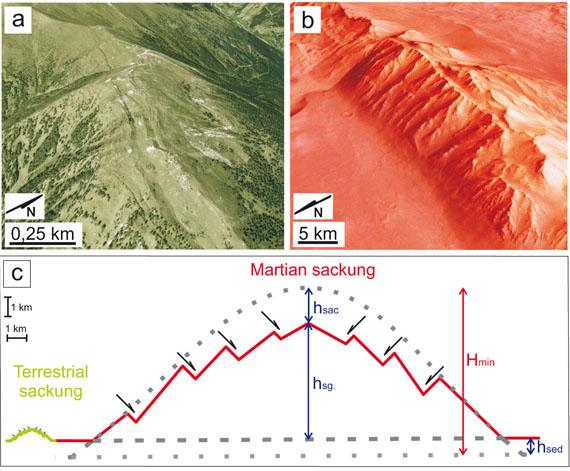 |
Olga graduated from University of Poznan and joined the Institute of Geological Sciences of PAS for working on the tectonics and geomorphology of the Valles Marineris canyons on Mars. She is especially interested in gravitational spreading of the topographic ridges within the Valles Marineris chasmata. The topic of her Master's thesis was a comparative study of gneisses from the Orlica-Snieznik dome in the Sudetes range. Her Martian work is supervised by Andrzej Zelazniewicz, Joanna Gurgurewicz and myself at PAS, and also Antoine Lucas at CEA in Saclay.
Joanna Gurgurewicz
Planetary geology and mineralogy
|
a,b: Quaternary basaltic flow in the Udokan volcanic field, east of Lake Baikal, Russia. b,d: Neogene basaltic flow near Gode, central Ogaden, Ethiopia. The features of alteration in these two extreme environments have been studied. |
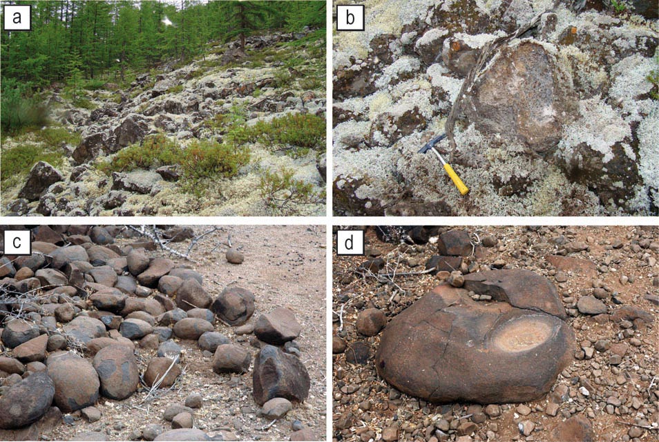 |
Joanna defended a master degree at the Institute of Geological Sciences of Wroclaw University, then a PhD in 2007 at the Space Research Center of the Polish Academy of Sciences in Warsaw on mineralogical, petrological, and structural characterization of Noctis Labyrinthus on Mars using using both visible and multispectral imagery (MOC, HRSC) and spectrometrey data (OMEGA, PFS). Dueinf her PhD she compared basalts from Noctis Labyrinthus and basalts from lake Baikal in Siberia that were sampled during two field works.
Within the framework of a one-year postdoctoral funded by Région Pays de la Loire, Joanna worked at LPGN on spectral characterization of basalt alteration in extreme morphoclimatic conditions: periglacial with her Baikal samples, and hot and arid with Ogaden basalt samples. Infrared spectra in wavelengths similar to the wavelengths obtained by the OMEGA and CRISM spectrometers orbiting Mars have been obtained for these samples, and have been interpreted with the help of chemical analyses (X-ray diffractometry and Raman spectrometry). This work aims at better understanding the alteration conditions of Martian basalts as viewed by the OMEGA and CRISM spectrometers, especially in the Valles Marineris-Noctis Labyrinthus region. This work has been carried out with other researchers at LPGN: Véronique Carrère and Stéphane Le Mouélic for IR spectrometry, and Anne Gaudin and Yann Morizet for X-ray diffraction and Raman spectrometry.
Since January 2010 Joanna is a researcher at the Institute of Geological Sciences and the Space Research Centre of the Polish Academy of Sciences (PAS). We are still working on this project within the framework of the new planetary geology group hosted at PAS and funded by the Foundation for Polsh Science.
Antoine Lucas
Granular flow modelling of landslides
In 2006 Antoine Lucas enrolled for a PhD work at Institut de physique du globe de Paris (IPGP), with Anne Mangeney and myself as supervisors. Antoine has done a breathtaking work on granular simuation of landslides on Earth and Mars. One of his promising results has been that the geometry of landslide failure plane (i.e. the scar shape) can be retrived from the geometry of the landslide deposits. He showed also that runout length is independent from the failrue plane geometry. He showed that similar to most terrestrial landslides, the friction angle is systematically very low, around 10°. Antoine found that a correlation exists between the geologic setting of landslides in Valles Marineris on Mars and the geometry of their failure plane, with higher mean fault dip angle for landslides that nucleated from anti-slope scarps of deep-seated gravitational slope deformation systems (sackung). Another of Antoine's major results was to show that seismic recordings of landslides can be used to retrieve information on the mechanisms of landslide propagation.
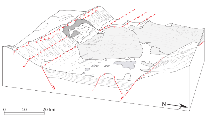
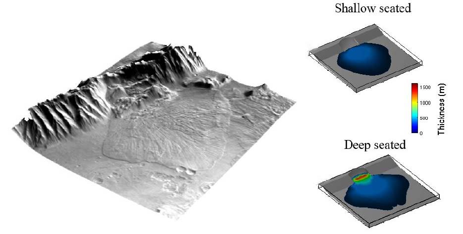
Three-dimensional interpretation of the Coprates Chasma landslide on Mars (upper figure) and result of a granular flow simulation (lower figure). The geometry of the deposits depends on the geometry of the failure plane: correct deposit geometry (lower right) is retrieved for a main fault dip angle of 56° (the simulation on the upper right is for a mean fault dip angle of 17°), consistent with landslide nucleation from a preexisting normal fault. This normal fault is actullay observed and is part of an anti-slope normal fault system along the topographic ridge. Such a correlation between landslide scar geometry and tectonic setting is found throughout Valles Marineris. More in (Lucas et al., 2011).
Antoine defended his PhD on March 30, 2010 at Institut de physique du globe de Paris. He obtained two postdoc positions, one at Lunar and Planetary Institute in Houston and another one at Caltech. Choosing was difficult but he finally joined Caltech where he is worked with Oded Aharonson. Since January 2013 Antoine has a postdoc position at AIM Laboratory (CNRS/CEA/Paris-Diderot University).
Laetitia Le Deit
Planetary geology and mineralogy
Laetitia was a student in Rennes then she moved to Nantes for a master degree. In 2005 she started her PhD work on the geological evolution of some of the Valles Marineris troughs on Mars (especially Candor Chasma). Using hyperspectral (OMEGA, CRISM), thermal (TES), and multispectral/visible images visible (Themis, HRSC, MOC, HiRISE) she investigated the correlation between mineralogy and geomorphology. Hyperspectral data were processes using three independent and complementary methods, improving the reliability of mineralogical interpretations. Laetitia's strength lies therefore in the ability in doing both high level geomorphology and mineralogy, which is not that frequent in planetary science. Laetitia is also good at field working. She particpated to a great work in the Ogaden, Ethiopia, during her PhD, to study Canyonlands graben-type mass wasting processes --there is an article in progress about this and the reason why it is not published yet is in great part my fault! At the PhD defence in 2008, Laetitia's work obtained work the highest distinction the University of Nantes can attribute.
Laetitia's Ph.D. thesis was also supervised by Olivier Bourgeois and Stéphane Le Mouélic. Since december 2008 Laetitia is a contractual researcher at DLR's Institut für Planetenforschung in Berlin.
A few figures extracted from her work:

Geomorphological and structural map of Candor Chasma in Valles Marineris, Mars.
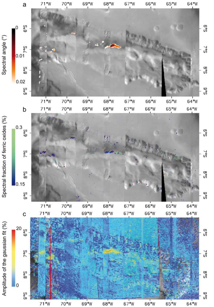
Illustration of the three spectral criteria used for the identification of minerals present at the surface from OMEGA spectrometry data: analysis of the spectral angle between image pixels and typical spectra from a spectral library (top), pixel spectrum modelling by the best linear combination of library spectra (middle), and comparison between pixel spectral topography and location of absorption bands for typical library minerals (bottom).

An interpretation of the iron oxides and sulfate deposits detected in Candor Chasma, one of the largest canyons in Valles Marineris, by OMEGA orbital spectrometer.
Gabrielle Bouvet
Geology of the Red Sea viewed by Henry de Monfreid
In 2008 Gabrielle Bouvet fulfilled her first year of master, her research work (TER) was on the analysis of the geological observation skills of the French writer, journalist, and adventurer Henry de Monfreid from his autobiographical works (Mer Rouge, Grasset, 2002) and log book (Aventures extraordinaires (1911-1921), Arthaud, 2007). Gabrielle's report, which was examined by Henry de Monfreid's grandson Guillaume de Monfreid, is the first analysis of this aspect of Henry de Monfreid works. Some geological questions raised by Monfreid are still unsolved today, 100 years later due to the persistent difficulty of doing field work in the southern Red Sea (Red Sea islands and northern Afar).
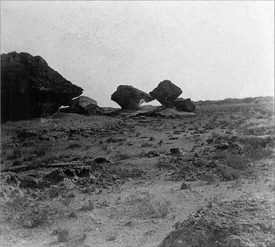 ©ADAGP, Paris 2009/ Archives Henry
de Monfreid
Gabrielle prepared the second year of her master degree in 2008-09 in Nantes in cartography and environmental management. She did some work on synthesizing studies on wind plants impact assessment using GIS techniques.
By the end of 2009 Gabrielle worked in a GIS consulting company in southern France; now she is managing wind power plant projects in Normandy.
Teodolina Lopez Gonzalez
Gravitational spreading
Within the framework of fulfillement of her first year of master degree Teodolina Lopez Gonzalez 1 did some mapping and geomorphometric analysis of the Chebis plateau of western Ogaden. This sedimentary area had never been studied before (as shown by the fact that the most recent geological maps indicate a huge basaltic plateau!) Using field data collected by Tewodros and me in 2005, satellite imagery (Landsat Geocover 1990 and Geocover 2000 obtained from the Global Land Cover Facility, plus ASTER), Teodolina drew in her master's first year thesis the first geological map of this area and proposed a gravitational spreading interpretation for the observed dramatic tectonic activity.
The Chebis plateau is part of the Audo Range, which we are studying with the framework of a broader gravitational spreading study of the western Ogaden with Laetitia and Tewodros. See the Ogaden gravity spreading section for an update of this work, which includes comparison with the Kebenawa Ridge, another mountain of the Audo Range), and the grabens from the Nedles District, Canyonlands National Park, Utah.
|
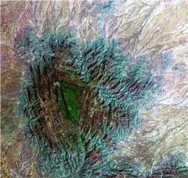
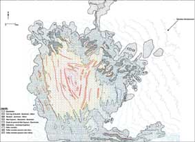
Left: the Chebis plateau in western Ogaden as observed by Landsat ETM+ ( Geocover 2000 mosaic). Right: Teodolina's geological map, discussed in her master's degree report. |
|
For the second year of her master degree Teodolina entered the planetary science field. She compared the fluvial-lacustrine networks of Titan with the pan (temporary lakes) of Namibia under the guidance of Olivier Bourgeois. Then she moved for a PhD. thesis at the Laboratory of Terrestrial and Planetary Dynamics at University Paul Sabatier (Toulouse). Under the guidance of David Baratoux and Michel Rabinowicz she has been working on the influence of the Martian crust heterogeneity on hydrogeological flow. After a 1-year post-doc stay working on Mars at University of Nantes, she is back in Toulouse where she is starting (Fall 2012) a work on identication of groundwater flow in the TIbesti volcanic field, Sahara, using infrared data with Michekl Rabinowicz.
Tewodros Rango Godebo
Hydrogeology
Tewodros followed the master of GIS and Remote Sensing of Addis Ababa University (AAU), where in 2004 he studied the hydrogeology of the Bale Mountains, east of the Ethiopian rift. This work, which was ranked first (placed equal), had two advisors, Tesfaye Korme (AAU, now Director of GIs and remote sensing at the Regional Centre for Mapping of Resources for Development in Nairobi) and me. Tewodros has participated to several of my field campaigns in various places of Ethiopia in 2004, 2005, 2006, and 2008. In March 2009 he defended a PhD at University of Ferrara on the influence of composition of catchment rocks on the chemistry of water in lakes Ziway, Langano, Abijata, and Shala in the rift valley. His first article demonstrated that high fluoride concentration resulting from leaching of rhyolite glass produced by rift valley volcanism makes these water unfit for human consumption.
|
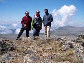
At the top of the periglacial Sanetti plateau, one of the highest summits in Africa (4400 m): from right to left: Tewodros Rango, Laetitia Le Deit, and me. |
Since 2010 Tewodros has a contract at Nicholas School of the Environment, Duke University, Durham, NC, and is working in the field of geohealth in the Ethiopian rift valley.


