Krzysztof Dębniak

krzysztof.debniak twarda.pan.pl
Research
topics
Valles Marineris geomorphologic mapping
Valles Marineris geomorphologic mapping
BACKGROUND
Why is Valles Marineris so important to us and what do we do with it?
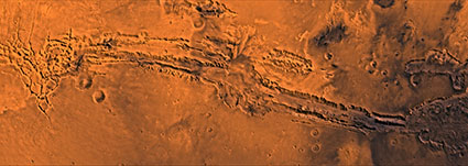
Fig. 1 Mosaic of Valles Marineris images, Viking mission
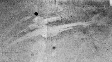
Fig. 3 Valles Marineris first image, Mariner 9, 1971
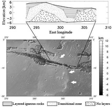
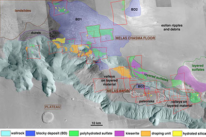
Fig. 4 Layered igneous rocks in Coprates Chasma
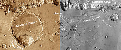
Fig. 6 Geomorphological landforms related to water flow and ice, Ganges Chasma
RESEARCH GOALS AND METHODS
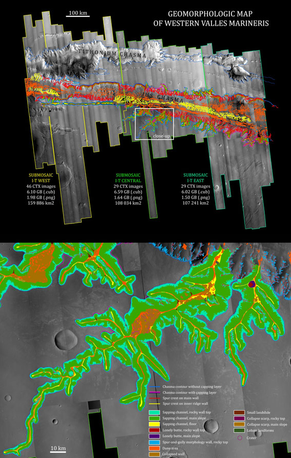
The main purpose of my work is to create a geomorphologic map of the western part of Valles Marineris (Fig. 7). In addition, I am preparing a synthesis of the geological history of the entire trough complex on the basis of previous studies and my current findings.
Valles
Marineris extends over 650 km x 2000 km in the equatorial
part of Mars. Internal trough landforms inform on 4 Gy of
Mars’ history, recording a broad range of magmatic,
tectonic, fluvial, lacustrine, glacial, eolian, and
gravitational processes. The investigated area includes Ius,
Tithonium and western Melas chasmata, where trough contours,
landslide scarps and main geomorphological bodies, ILDs,
dune areas, sapping channels, spur and gullies, floor
features, and different wall types are mapped.
The background mosaic was created on the basis of 100 Context Camera (CTX) images obtained by the Mars Reconnaissance Orbiter (MRO). The image processing has been fulfilled using the ISIS Planetary Image Processing Software, including five sub-programmes: mroctx2isis, spiceinit, ctxcal, ctxevenodd, cam2map and isis2std. The images have become georeferenced, radiometrically calibrated, devoid of dead pixels, and projected. During these changes the image resolution was decreased from 6 to 12 m/pixel. In order to enable ISIS software to match file size limitations for the mosacing process (indicated in brackets), the image collection was divided into three smaller sets (western, central and eastern). Each set was adjusted by tone matching equalizer and mosaic creating automos (12 GB), and eventually converted to PNG file in isis2std (2 GB). Additionally, MRO HiRISE images, Mars Global Surveyor (MGS) MOLA altimeter datasets and MGS Mars Orbiter Camera (MOC) images were also used for interpretation.
During the past year, I have mapped a number of geologic and geomorphologic features, i.e. dune areas (Ʃ >10 000), craters (Ʃ >5000), sapping channels (rocky wall top, main slope, floor), pit chains, walls of spur-and-gully morphology, large landslide scarps, collapsed rocks of landslides (8 types), lonely buttes, small landslides, collapsed walls, boulders, lobate landforms, tongue-shaped landform, valley infill, spur crests on walls (Ʃ 12 439 km), chasma contours (Ʃ 8866 km), periglacial floor landforms, evaporate-like floor areas, and other floor features.
Dune areas cover a significant part of chasma floor, but they are not a homogeneous unit. Valles Marineris dunes are characterized by different: type (barchans, transverse dunes, longitudinal dunes), lithology (bright and dark dunes), exposure size of single dune area (from ~100 m2 to ~100 km2), and sand source. Among 20 largest dune fields on the Ius Chasma floor, the average dune spacing (measured between crests) is 50 m and the predominant facing direction of dune slopes is W-E. These transverse and longitudinal dunes are built of sand from intra-chasma main sources (landslides, walls) and secondary sources (interior layered deposits (ILDs), floors and craters). Dunes originated in landslides dominate in the northern trough, whereas wall-related dunes are widespread in the entire chasma. Floor source is a stratigraphically homogeneous unit observed in the southern Ius trough, probably of detrital origin, in which dunes occupy erosional hollows. Crater dune fields are rare.
Analysis of spur and gully morphology has revealed three chasma wall types: active (with a visible evidence of modern sediment transport; common), inactive (with a lack of transport; rare) and grooved (displaying up to 100-meter wide shallow flat-floored linear grooves parallel or oblique to the local slope; common on the central Ius inner ridge). The grooves might result from a creeping process of viscous surface material.
Glacial and periglacial landforms were determined in the western part of Ius Chasma. The area consists of three regions: moraine area, till plain, and outwash plain, localized in accordance with the floor inclination.
Sapping channel systems are present mostly in the southern part of Ius Chasma. They are characterized by different length (14-150 km), area (47-2270 km2), sinuosity (1,0-1,2), number of branches (1-20), and maturity (number of collapsed walls inside). In one system, tongue-shaped flowing feature (probably periglacial) was determined.
Systematic high-resolution mapping in Valles Marineris is revealing geomorphologic features and processes that had not been recognized before. I will present full mapping results in June 2015.
REFERENCES
- Carr M. H., Head III J. H., 2010, Geologic history of Mars, [in:] Earth and Planetary Science Letters, vol. 294, p. 185-203;
- Coleman N. M., Baker V. R., 2009, Surface morphology and origin of outflow channels in the Valles Marineris Region, [in:] Burr D. M., Carling P. A., Baker V. R., 2009, Megaflooding on Earth and Mars, p. 172-193;
- Deit Le L., Mouélic Le S., Bourgeois O., Combe J.-P., Mège D., Sotin C., Gendrin A., Hauber E., Mangold N., Bibring J.-P., 2008, Ferric Oxides in East Candor Chasma, Valles Marineris (Mars) inferred from analysis of OMEGA/Mars Express Data: identification and geological interpretation, [in:] Journal of Geophysical Research, vol. 113, E07001, doi: 10.1029/2007JE002950;
- Faure G., Mensing T. M., 2007, Mars: the little planet that could, [in:] Introduction to planetary science, p. 211-259;
- Fortezzo C. M., Platz T., Michael G., Robbins S., 2012, Geologic history of Valles Marineris, Mars, Revisited, [in:] 43rd Lunar and Planetary Science Conference, Houston, Texas, no. 2821;
- Hartman W. K., 2003, A traveler’s guide to Mars;
- Kargel J. S., 2004, Mars – a warmer, wetter planet, p. 51-59;
- Masson P., Carr M. H., Costard F., Greeley R., Hauber E., Jaumann R., 2001, Geomorphologic evidence for liquid water, [in:] Space Science Reviews, vol. 96, p. 333-364;
- Mège D., Bourgeois O., 2011, Equatorial glaciations on Mars revealed by gravitational collapse of Valles Marineris wallslopes, [in:] Earth and Planetary Science Letters, vol. 310, p. 182-191;
- Murchie S. L., Johnson J. R., Seelos F. P., 2012, MRO/CRISM observations on Interior Layered Deposits of Tithonium Chasma, Mars, [in:] 43rd Lunar and Planetary Science Conference, Houston, Texas, no. 1553;
- Peulvast J.-P., Mège D., Chiciak J., Costard F., Masson P. L., 2001, Morphology, evolution and tectonics of Valles Marineris wallslopes (Mars), [in:] Geomorphology, vol. 37, p. 329-352;
- Rossi A. P., Komatsu G., Kargel J. S., 2000, Rock glacier-like landforms in Valles Marineris, Mars, [in:] 31st Lunar and Planetary Science Conference, Houston, Texas, no. 1587;
- Scott D. H., Tanaka K. L., 1986, Geologic map of the western equatorial region of Mars;
- Warner N. H., Sowe M., Gupta S., Dumke A., Goddard K., 2012, Connecting Valles Marineris to the Northern Plains: linkage by lake overspill and catastrophic flooding, [in:] 43rd Lunar and Planetary Science Conference, Houston, Texas, no. 1237;
- Weitz C. M., Williams R., Noe Dobrea E., Baldridge A., 2012, Hydrated minerals and fluvial features in and around the Melas Chasma Basin, [in:] 43rd Lunar and Planetary Science Conference, Houston, Texas, no. 2304;
- www.esa.int/SPECIALS/Mars_Express/SEMWBK73R8F_0.html (Noctis Labirynthus)
- www.esa.int/SPECIALS/Mars_Express/SEMH916LARE_1.html (Kasei Valles)
- www.esa.int/SPECIALS/Mars_Express/SEM9MZW4QWD_0.html (Eos Chasma)
Profile
EDUCATION
2012 – present: PhD student in Planetary Geology
> Polish Academy of Sciences
> Institute of Geological Sciences, Research Centre in Wrocław
> Research topic: A geological synthesis of Valles Marineris
2009 – 2011: Master in Geology
> University of Wrocław
> Faculty of Earth Science and Environmental Management
> Majoring in Hydrogeology
> Thesis: The role of carbonate rocks in water circulation: example of catchment area of Jaskiniec stream
2008 – 2010: Master in Oceanography
> University of Gdańsk
> Faculty of Oceanography and Geography
> Majoring in Marine Geology
> Thesis: Gas hydrates – a future energy resource
2005 – 2008: Bachelor in Oceanography
> University of Gdańsk
> Faculty of Biology, Geography and Oceanology
> Majoring in Marine Geology
WORK EXPERIENCE
January – July 2012: Junior Geological Specialist
> Polish Geological Institute, National Research Institute – Department of Marine Geology, Gdańsk, Poland;
> Responsible for geochemical laboratory tasks, sediment core samplings, sedimentary analyses and a database administration of the Mountains Landslides Database.
September – November 2011: Assistant in field research in engineering geology
> Pracownia Geologiczna “Mr. Geo”, Gdańsk, Poland;
> Responsible for percussion drilling, characterizing soil properties with the use of an impact penetrometer, geohazard assessment.
August – October 2010: Cartography and GIS apprentice
> Winterresie e.U., Rum near Innsbruck, Austria;
> Responsible for the creation of vector maps using MapEditor programme; my tasks included working with satellite images, archives, digital data bases and other cartographical papers.
July 2008: Summer camp educator
> Harctur Gdańsk, Poland.
April 2007: Volunteer
> European Cetacean Society’s International Conference, San Sebastian, Spain;
> Voluntary work for the 21st Annual Conference; the job entailed working on the preparations and successful course of the conference.
TRAININGS
2011: Workshops: Pomeranian Platform of Innovative Science-Industry Cooperation – Projects management, Effective applying for investigational grants, Writing scientific papers, Modern presentations; Gdynia, Poland.
2008: Course for summer camp educators, Słupsk, Poland.
2008: Training workshops: Photography and film in underwater nature documentation, organized by: Department of Marine Biology and Ecology, Institute of Oceanography, University of Gdańsk.
CONFERENCES
May 2012: Presentation entitled Gas hydrates – a future energy resource given during the Fourth Symposium of the Sopot’s Youth Forum, which was organized by the Institute of Oceanology of the Polish Academy of Sciences. I was awarded the prize for best natural science’s presentation.
RESEARCH FIELD TRIPS
September 2012: Tatra Mountains, Poland – measurements of deep-seated gravitational features as analogues of Martian sackungs.November 2009 – December 2010: Złote Mountains, Poland – spring and stream hydrometric measurements, water physical and chemical variables measurements, water samplings.
May 2009: Aland Islands, Finland – rapakivi granite samplings, photos acquisition designated for the Pleistocene glaciers movement database.
May 2008: Rügen, Germany – a chalk cliffs sampling (co-organizer; author of the article Wszechoceanu badacze nieprzypadkowi / Non-accidental researchers of the World Ocean, [in:] Gazeta Uniwersytecka, June 2008, No. 6, Vol. 99, p. 14-16; author of the summarizing presentation during the Institute of Oceanography seminar session).
< Back

