Daniel MEGE
RESEARCH


Gravitational spreading on Mars: Evidence for ancient equatorial glaciers?
Read the corresponding article published in Earth and Planetary Science Letters (2011).
February 2011 update: Paper presented at the International Association of Geomorphologists Meeting, February 11, Addis Ababa
Mars has a huge system of interconnected depressions, basically grabens, Valles Marineris. Horsts are intercalated with the grabens (see the articles Mège and Masson, 1996, Peulvast et al., 2001 in the Publications section), and most of them display sackung (Deep-Seated Gravitational Spreading) features that were presented at the 36th Lunar and Planetary Science Conference in 2005 (abstract, oral presentation). Note that the interpretations given in 2005 do not exactly match my recent interpretations, especiallyt in terms of stratigraphy.
Based on the morphoclimatic conditions prevailing in most sackung sites identified on Earth whose genesis has been published in refereed journals, it seems that the sackung features observed in Valles Marineris requires glacial conditions throughout the chasmata (big troughs). The chasmata should have been filled by valley glaciers having a height of several hundred meters or more. Below is the content of my abstract presented at the 41th LPSC (March 2010). The oral presentation gives additional details (the downloadable version of the presentation includes several online-only slides that were not included in the presented talk for time constraints). For a lab science meeting on June 15, 2010, a poster that summarizes and slightly updates some results was prepared and is also available (in French):
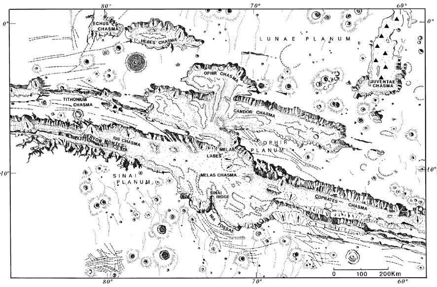
But first, Valles Marineris looks like this (from a drawing by Mrs. Geneviève Roche, Paris-Sud University). The chasmata are 2 to 10 km deep:
Sackung in Valles Marineris
Sackung is a mechanism of topographic ridge destabilization that produces normal fault scarps on ridge flanks and spectacular ridge-top splitting at summit, resulting in diagnostic narrow crestal grabens [2-6]. A breathtaking example has been identified at Geryon Montes, the central Ius Chasma horst [1]. A systematic study along Valles Marineris reveals that sackung is actually observed at almost every horst within Valles Marineris, which includes horsts at the western Coprates Chasma, Melas-Candor, and Candor-Ophir boundaries, and in Candor Chasma [7].
As an example, the Geryon Montes ridge displays a crestal graben (Figure
1, top) and ridge-parallel normal faults along its southern slope. Normal
faulting has not affected the northern slope of the ridge, as expected
from the asymmetric nature of sackung. Observed ridge-parallel floor anticlinal
folding and probable thrusting at the base of the ridge [1] is predicted
by sackung experiments [5,6,8,9], and observed in terrestrial sackung
examples as a result of downward displacement of the sagging slope [10]
as an alternative or complement to the more commonly observed slope overbulging
[4,11].
Sackung mechanisms from Earth-based analogues
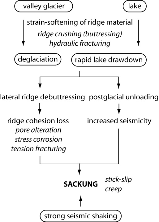
On Earth, ridge-top splitting has been almost exclusively observed in mountain ranges that were glaciated during the Quaternary, where they have been ascribed to ridge debuttressing after glaciation, and/or postglacial unloading (Figure 2). In an extensive search for sackung studies on Earth, 23 articles explicitely discussing the sackung triggering mechanisms have been found to be published in peer-reviewed articles, representing as many distinct sackung sites. Of these, 20 have been explicitly ascribed to postglacial processes (the Alps of Europe, Japan, and New Zealand; the Canadian and U.S. Rockies; the Cascade, Andean, and Pyrenean Ranges, and the Himalayas), 2 to seismic activity along the nearby San Andreas fault system (the sackung interpretation of the observed faults being controversial in 1 of the 2 cases), and 1 to an unknown mechanism (southern Apennines in Italy). Lacustrine ridge buttressing followed by rapid lake withdrawal is a variation on the glaciation-deglaciation mechanism that appears to be able to trigger sackung in theory but does not appear to have been identified on Earth [12].
 |
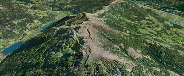
Figure 1. Two examples of ridge-top splitting. Top : Geryon Montes in Ius Chasma; bottom: Bodeneck in the Austrian Alps. Note the glacial valleys on both sides of the Bodeneck ridge. Ridge width is 20 and 8 km respectively. Images are from Mars Express/HRSC and Spot 5. There is no scale distortion. |
 |
In the postglacial environment, the mechanisms that link ridge debuttressing and sackung have not been fully understood to date; nevertheless, rock decohesion by alteration and formation of clay minerals accumulating at the bottom of the crestal graben scarps [2], or selectively weaken lithological sequences [13] probably plays a major role in ridge slope destabilization. It appears reasonable to suggest that ridge confinement by valley glaciers and saturated or nearly-saturated water conditions in the ridge rock mass is directly related to ridge weakening through stress corrosion and subcritical crack growth. In some circumstances, such as during melting/freezing cycles, hydraulic fracturing might also be involved.
 |
|
Figure 2. Genesis of sackung features. Of 40 terrestrial sackung sites investigated and published in peer-reviewed articles (number updated on June 15, 2010), 37 have been attributed to glaciation/ deglaciation, 2 to seismic shaking along a nearby fault (the San Andreas fault), and 1 (in the Apennines) has not been elucidated despite several geophysical investigations. |
Comparison between ridge-top splitting in Valles Marineris and formerly glaciated valleys in the European Alps is amazing (Figure 1). We argue that sackung in Valles Marineris is most likely due to deglaciation of the horst-surrounding grabens, because of the excellent statistical correlation between sackung occurrence and deglaciation on Earth.
Correlation with mineralogical models
CRISM data modeling has revealed sulphates and hydrated silica on chasma floor below the Geryon and other sackung sites [14,15]. This association has been convincingly interpreted as the product of silicate material weathering in massive ice deposits [16].
Trimlines
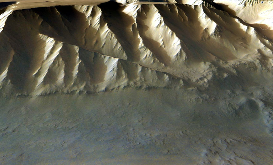
Supporting this interpretation is the possible existence of glacial trimlines at the bottom of the slope of many chasmata (Figure 3). The associated scarps were first interpreted as normal fault scarps [7]. However, evidence of fault offset variation along length, and scarp end tapering off [18], which would confirm this interpretation, is usually lacking. If the trimline interpretation is correct, its elevation above chasma floor gives an idea of valley glacier thickness. This thickness would be ca. 1300 m in the area displayed on Figure 1, i.e. 15% of the chasma height. For a given glacier, the trimlines are expected to define a planar surface, a feature that will be investigated in more detail for Valles Marineris before the conference.
 |
||
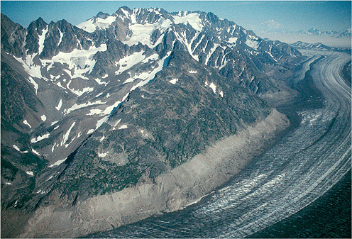 |
Figure 3. Top: Ius Chasma slope north of the area displayed on Figure 1. The length of the putative trimline (horizontal rock outcrop) above the basal scarp is 10 km. Bottom: trimline above the Tana glacier, Alaska, showing the maximum elevation the glacier has reached [17]. |
|
Conclusion
Large-scale gravitational spreading of the inter-chasma ridges suggest that the Valles Marineris chasmata were once extensively covered by valley glaciers. It has been suggested that these ridges have unusual high strength, gained by groundwater fluid circulation and cement precipitation within the rock mass [19]. The results presented here argue in favor of spectacularly low cohesion ridges instead, but unambiguously supports the idea that groundwater should have once been abundant within the ridges.
References
[1] Mège D., Peulvast J.-P. and Masson P. ( 2005) LPS XXXVI, Abstract #1772.
[2] Kobayashi K. (1956) Biuletyn Periglacjalny, 4, 15-36.
[3] Beck A.C. (1968) New Zealand J. Geol. Geophys., 11, 191–199.
[4] Hippolyte, J.-C., et al. (2006) Tectonophysics, 418, 255-276.
[5] Ambrosi C. and Crosta B.G. (2006) Eng. Geol., 83, 183-200.
[6] Bachmann D. et al. (2009) Geomorphology, 103, 130-135.
[7] Peulvast J.-P. et al. (2001) Geomorphology, 37, 329-352.
[8] Morgan J. K. and McGovern P. J. (2005) J. Geophys. Res., 110, B05402.
[9] Kinakin D. and Stead D. (2005) Geomorphology, 65, 85-100.
[10] Guerricchio A. and Melidoro G. (1979) Geol. Appl. Idrogeol., 14, 13-22.
[11] Reitner J., Lang M. and van Husen D. (1993) Quaternary Int., 18, 43-51.
[12] Rogers J. D. and Watkins C. M. (2003) http://web.mst.edu/~rogersda/sturzstroms&sackungen (checked on Jan. 23, 2011).
[13] Beget J. E. (1985) Arctic Alpine Res., 17, 143-152.
[14] Roach L. H. et al. (2009) LPS XL, Abstract #1834.
[15] Gendrin A. et al. (2005) Science, 307, 1587-1591.
[16] Niles P. B. and Michalski J. (2009) Nature Geosci., 2, doi:10.1038/ NGEO438.
[17] Molnia B. F. (2004) U.S.G.S. Open-File Rept 2004-1216.
[18] Cowie P. A. et Scholz C. H. (1992) J. Struct. Geol., 14, 1133-1148.
[19] Treiman, A. (2008) Nature Geosci., 1, doi:10.1038/ngeo131.

